
Taroko National Park was established in 1989 as part of an environmental protection movement in the area. The mountains were being stripped so the government stepped in and this park was established to protect the natural resources and beauty of the area. The park has about 225,000 acres and is one of only a handful of U shaped valleys in the world (the Grand Canyon being one of them). I've included a website you can check out to learn more. Taroko
Taroko means "magnificent and splendid" in the language of the Truku and that it is.


It is so hard to capture the scale of these cliffs!

There was such interesting vegetation everywhere; some of it was completely primordial.

This is Celeste. She was one of the best guides I've ever had. She gave us so much history and information but also let us get out everywhere to hike and explore on our own.

Roads and paths are build into the side of the mountain (much of it made of marble) and this is one of the shots I took looking out into the valley. Doesn't it look like a face!?


This rock formation is called Yindianren (Indian) Rock because it's a profile of a face. Can you see it?


Dotting the landscape are little temples, pagodas and statues.


Look at this structure built completely into the rock face of this mountain!

This area was called Swallow Grotto. The marble cliffs have thousands of holes where swallows once nested. Now, because of so much construction in the area and tourists, there are not as many swallows but they park is restricting some activity in hopes that the swallows return.


We all had to wear these construction helmets to protect ourselves from possible falling rocks. Attractive!


You can see the marble striations and texture throughout the valley but especially where natural springs run over the rock. These mountains were formed when they rose out of the sea and they continue to rise at a rate of about 1/2 a centimeter a year. Marble is a metamorphic rock. It was once limestone and turned into marble under high heat and pressure. As the mountains continue to rise, the river and rainwater continue to erode the rock to form this dramatic vistas. Sorry for the science lesson but the geek in me LOVES this stuff! It truly is a remarkable geological process that created this valley.

This is the path we walked that wove through the mountain. INCREDIBLE!


You can see all of the little (and not so little) holes where the swallows used to live.

It was great that so many of the signs were in both Chinese and English.

Can you imagine carving miles of road out of marble?!

This is a shot down to the river below. The water was this soft aquamarine blue.


I truly just want to venture into the many caves I saw along the valley.

That is a suspension bridge that crosses the gorge. They only allow 60 people a day to cross over to the other side. They truly are trying to protect this area as much as possible.


I so love the signs in this country.


It looks a bit like snow covering the mountain but those are clouds - truly beautiful! We headed further up into the mountains and went to a local restaurant for lunch where we enjoyed more aboriginal cuisine. Celeste left us there and told us she would meet us down at the bus station/visitor center. We ventured down from the restaurant and found this little trail off the beaten path.


My mother used to grow these in her living room. I didn't know that they grew to about 5 feet in height!

These were the views along this little narrow trail.

Yes, these are poinsettias!

At the end of the trail was this view of a pagoda and statues in the distance.


There is this little church located in this park that I plan on visiting next time I'm here.

That's a suspension bridge in the distance.


I still can't get over that it is the end of November and I get to see this color! Well, at least the pointsettias are a Christmas flower.

We finally made it down the mountain to meet up with Celeste and she took us to the Eternal Spring Shrine, which was built to honor the men who died building this road. She drove us through the Tunnel of Nine Turns and dropped us off to walk to this shrine. The 45 foot high waterfall flows through the shrine and down the mountain. There is a steep trail behind the shrine the leads up the mountain and to the other shrines (that's one of them below) and a suspension bridge on the other side.


It's hard to tell from the picture above but you can make out the path up the mountainside above the shrine. I made it about halfway up.


You can see the road carved into the side of the mountain and the shrine way up above.


As you walk toward the shrine, there is a room with these 3 statues and it leads to the tunnel below. Much of the walkways and trails were not built for taller people. Maybe that's why this man is holding his head.


Stairs...


stairs....

and more stairs.


This statue is built into this crevice that is at the entrance to the path going up the mountain.

The steep stairs/path behind the temple, called the sky ladder, goes up for 2.2 kilometers. I went up about 200-300 steps and I turned back around. I plan on getting up there the next time I head to this area. I guess the views of the Central Mountain Range are stunning from up there and it would be cool to cross the suspension bridge and visit the other temples. Again, I can't imagine building this staircase! I had to duck to protect my head on several occasions.


.jpg)

Do I really want to venture out there? Of course I do!


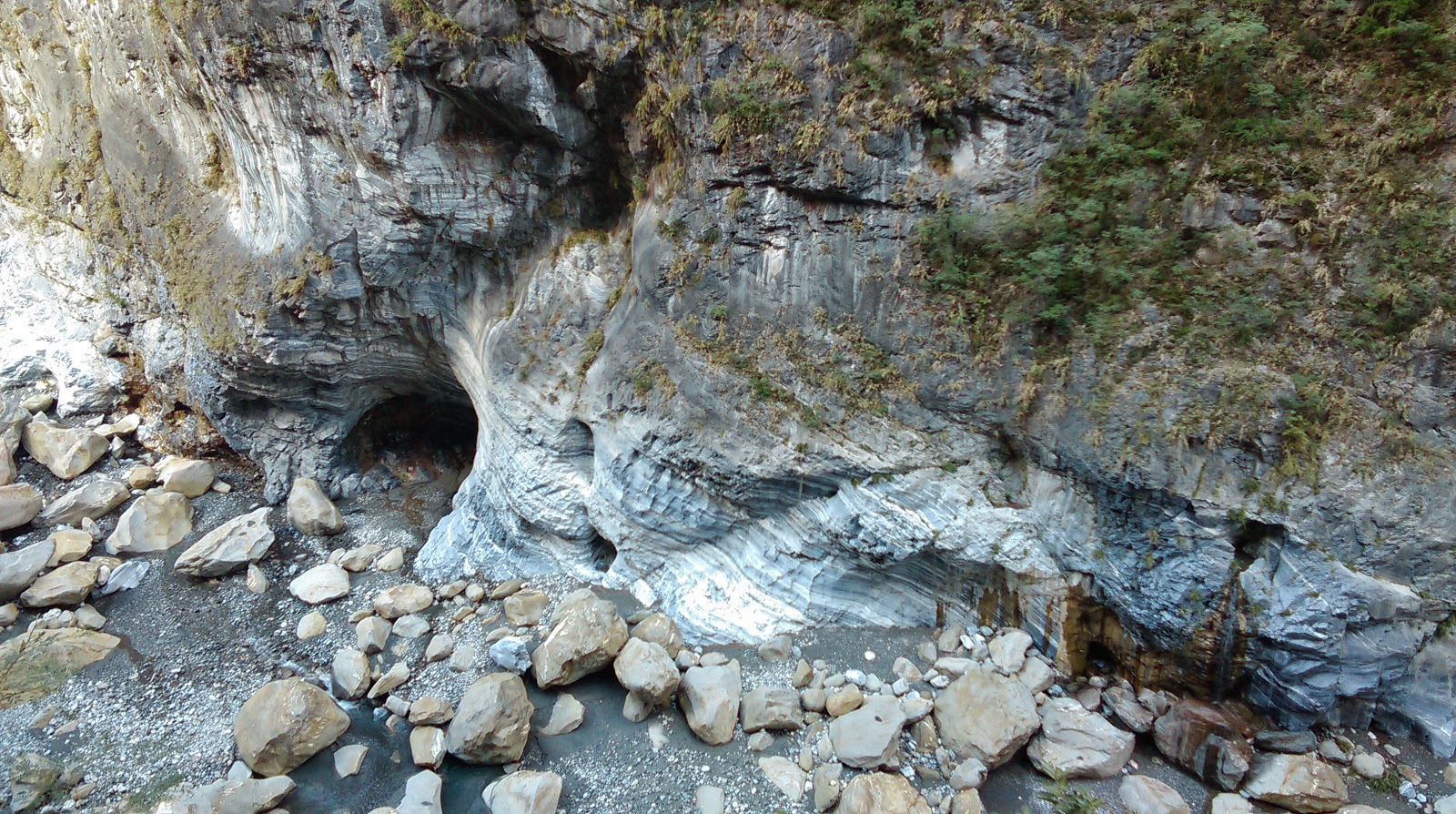
This photo looks like a giant creature is about to have a little snack. Open Wide!
I had to duck down on several occasions during this walk. The path meanders along the Shakadang stream and it was so tranquil and serene (until the busloads of Chinese tourists invaded the quiet space). There are several signs informing us that this trail is used by the aboriginal people to transport goods. Apparently there is a Truku tribal village at the end of the trail. Entrance to the village is prohibited but local artisans and food vendors have a small market at the entrance to the village. I wish we had known that but it's about an hour walk from the bridge and we didn't have enough time. Next time!


The stream has these massive boulders that are made completely of marble. AMAZING!

The water that flows is this amazing clear, turquoise color that was so inviting. I wish I could have taken a dip in one of those pools.

You can see how low these overhangs are.


We got back into the van and made our way out of Taroko National Park and to the ocean where the mountains meet the shore.


No comments:
Post a Comment